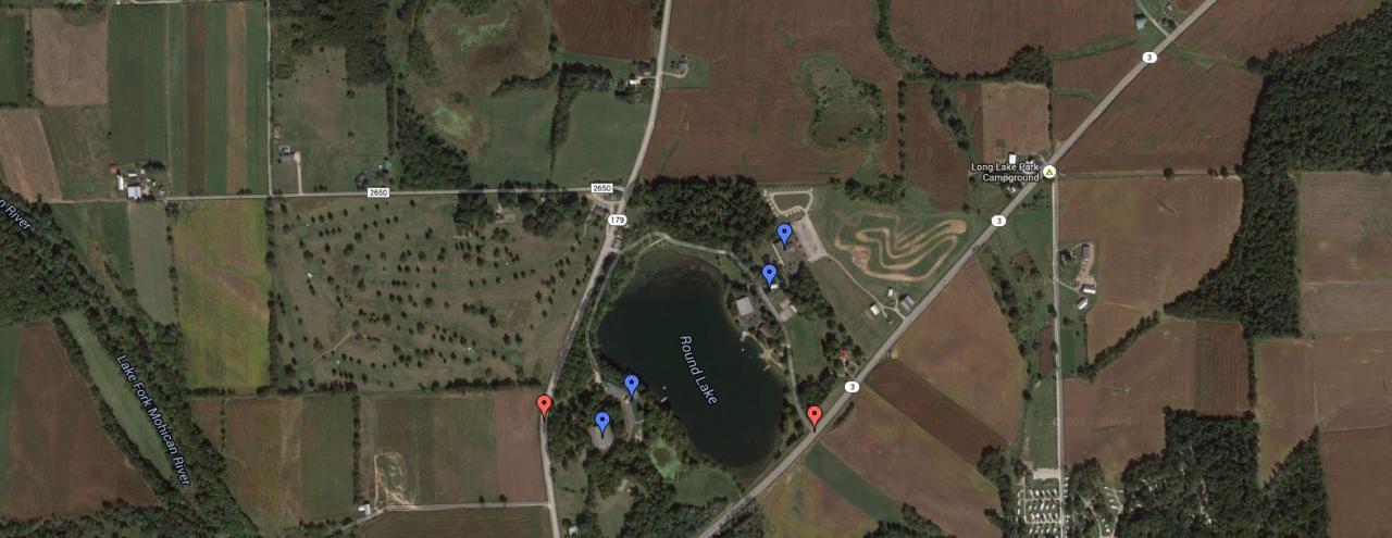
Directions to Round Lake
Camp Side Address: 114 State Route 3, Lakeville, OH 44638
Lodge Side Address: 2678 State Route 179, Lakeville, OH 44638
View Round Lake in a larger map
From Columbus, Ohio
Take Interstate 71 north to Mansfield. At Mansfield, take exit #176 (30-Mansfield/Wooster). Go east (right) towards Wooster on State Highway 30. Stay on State Highway 30 until you come to the Ashland/Hayesville-State Highway 60 exit. Coming off the exit ramp, go right on 60 to Hayesville (about 3/4 mile). Hayesville has one traffic light. At traffic light, go left, and you will be on State Route 179. Stay on 179 for 10 miles. When you come to Round Lake Golf Course on your right, the camp is on your left. Stay on 179 and the Lodge Side entrance is on your left—just after the Golf Course (.2 mile). To get to the Camp Side stay on 179 until you come to State Highway 3. Go left on 3 for 1/2 mile, and the Camp Side entrance is on the left.
Round Lake is approximately 1 hour and 45 minutes north of Columbus.
From Cleveland Hopkins Airport
Take Interstate 71 south to Exit 204 (State Route 83-Lodi/Wooster). Follow State Route 83 South to Wooster and take State Route 3 South State for about 15 miles. The Camp Side entrance will be on your right marked by a sign for the camp. Immediately after the sign is the lake on your right. For the Lodge, go past Camp Side entrance (stay on State Route 3) until you reach State Route 179 (first intersection, 1/2 mile.) Turn right on 179 and Lodge Side entrance is .3 of mile on the right.
From Mansfield, Ohio
Stay on State Highway 30 until you come to the Ashland/Hayesville-State Highway 60 exit. Coming off the exit ramp, go right on 60 to Hayesville (about 3/4 mile) Hayesville has one traffic light. At traffic light, go left, and you will be on State Route 179. Stay on 179 for 10 miles. When you come to Round Lake Golf Course on your right, the camp is on your left. Stay on 179 and the Lodge Side is on your left—Just after the Golf Course (.2 mile). To get to the Camp Side stay on 179 until you come to State Highway 3. Go left on State Route 3 for 1/2 mile and the Camp Side entrance is on the left.
From Ashland, Ohio
Go south on State Route 60 to Hayesville. Hayesville has one traffic light. At traffic light, go left, and you will be on State Route 179. Stay on 179 for 10 miles. When you come to Round Lake Golf Course on your right, the camp is on your left. Stay on 179 and the Lodge Side is on your left—just after the Golf Course. To get to the Camp Side stay on 179 until you come to State Highway 3. Go left on 3 for 1/2 mile, the Camp Side entrance is on the left.
From Canton, Ohio
Take 30 West to Wooster. Exit State Route 3 South-Loudonville Follow SR 3 south for approximately 15 miles. Camp Side entrance is on right side of State Route 3. For the Lodge Side entrance, go right onto State Route 179. Lodge is .5 mile on right.
Traveling North on St. Rt 3
South of Loudonville you will pass Mohican State Park on your left. Follow State Route 3 past Pizza Hut then McDonalds to the 1st traffic light. Turn right at traffic light to follow State Route 3. At the next traffic light turn left to continue on State Route 3. At the next traffic light by the Marathon Gas Station, turn right and stay on State Route 3 for approximately 5 miles. The Camp Side entrance will be on your left. For the Lodge Side, turn left onto State Route 179. The Lodge Side Entrance is about a quarter mile down to your right.
Directions to Wilderness Camp (Licking Co.) from Round Lake
16685 Frampton Rd, Frazeysburg, OH 43822
View Wilderness Camp in a larger map
Take State Route 3 South through Loudonville. Continue on State Route 3 to State Route 205 at Jelloway State Route 205 to 514 (Just North of Danville) (ball diamond will be on your right) State Route 514 for about ¼ mile into Danville At 4 way stop in Danville go straight onto 62 South (gas station will be on your right) Continue on State Route 62 to Martinsburg At Martinsburg there is 1 traffic light Go straight through traffic light and you will be on State Route 586 Continue on State Route 586 for about 7 miles Turn left on Frampton Rd. (Frampton Rd. only goes left or East) (You will be close to Frampton Rd. when you see old school buses on the right side.) Stay on Frampton Rd. for about 1.5 miles to covered bridge. Go through covered bridge.
* Continue on Frampton Rd. for ¼ mile. (you will see 2 oil tanks on your right.) In that vicinity is the parking. Immediately across Frampton Road from the oil tanks is a gravel drive leading to base camp. From Fallsburg to Wilderness Base Camp Take State Route 586 North to Frampton Rd. (Frampton Rd. is about 1 mile North of Fallsburg on the right) Take Frampton Rd. right (East) Stay on Frampton Rd. for about 1.5 miles to covered bridge Go through covered bridge. See last paragraph (*) above for exact directions.